

The Branscombe Project

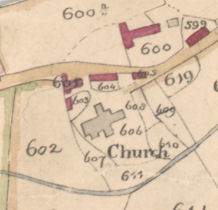
Alexander Law’s Map 1793
In 1793 the Dean and Chapter of Exeter commissioned Alexander Law to survey their holdings in Branscombe. Law lived from 1755 to 1840. He came from Aberdeen, and was apprenticed to the well-
The Branscombe map is both accurate and beautifully executed. Alongside the map, Law drew up a detailed list of all the farms, with the names, acreages and use of the fields. The list distinguishes between copyholders and leaseholders and gives all their names. It is an invaluable document and precedes the tithe map by nearly half a century. The only drawback, for someone using the map today, is that he didn’t include land that was privately owned and thus not part of the manor.
To view the whole map click on the image below
Click here to view apportionments.
Acknowledgements
We are very grateful to John Draisey of the Devon Record Office who was able to digitise the Law map for us, and to Angela Doughty of the Cathedral Archives in Exeter for permission to put the map and apportionments on our website.
| Archive Misc |
| Barbara Bender |
| Geoff Squire |
| John Torrance |
| Branscombe Parish Newsletter |
| Photographic Archive |
| Postcard Archive |
| Talks Page 1 |
| Talks Page 2 |
| Talks Page 3 |
| Talks Page 4 |
| Talks Page 5 |